Vía de la Plata, the legendary Roman “highway” that linked western Hispania

Roads are a comfort that is taken for granted nowadays. However, the massive development of this type of infrastructure is very recent. Radial highways from the A-1 to the A-6, routes that connect extreme points of the Cantabrian and the Mediterranean such as the A-7 or the A-8, national, secondary… All of them constitute an intricate map that reminds us of the circulatory system. Millennia ago, the Romans achieved something similar. Their roads kept the Empire alive for centuries. Via de la Plata was one of the most important in Hispania and its legacy is still alive.

Astorga, end of the Via de la Plata. | Shutterstock
The historical itinerary of Vía de la Plata is well studied and confirmed. It went from Augusta Emerita to Asturica Augusta, that is, from Merida to Astorga. A route that seemed to be travelled even before the arrival of the Romans. Thus, it has been related to Tartessos and Celtiberians. This way it would be a commercial route focused on the trade of goods such as tin. Scipiones’ irruption in Iberia during the Second Punic War marked the beginning of Roman control. Emporiae or Italica were early examples of this trend.
It is not clear where exactly the so-called Via de la Plata started to exist as a Roman road. Merida, the starting point, dates from 25 b.C. and Astorga, as such, from 14 b.C. It is believed that the road was promoted mainly by the Augusta and Antonina dynasties. Thus, Augustus himself, Trajan and Hadrian would have been its main promoters in the first century AD.

Roman bridge in Mérida. | Shutterstock
Moving between north and south was especially important in the change of era. On the one hand, the south and the Greek colonies were under total control, while the Asturians and Cantabrians put up fierce resistance. So south-north logistics were vital. Galicia and castros such as Baroña or Santa Trega were less opposed to becoming Romanised.
As the Roman imperial period progressed, Merida became the capital of the province of Lusitania. Meanwhile, Astorga became the head of the Conventus asturicensis, a legal jurisdiction of the province of Tarraconensis. Under Vespasian, Hispanics acquired Roman citizenship in 1970. As a result, the peninsula prospered more than ever. The crises did not prevent that in the 3rd century, when it was described in the Itinerary of Antoninus, the Silver Way remained the most important in Hispania. Such a document left a record of the roads of the whole empire.

Cáceres, city with a Roman origin in the Vïa de la Plata. | Shutterstock
When the barbarians assaulted the Roman territories, the roads turned against the empire. The fall of the western segment of the 5th century gave way to the Middle Ages. Visigoths and Swabians made use of the Via de la Plata for their conquests. As in the Asimov Foundation, the Germanic heirs of Rome safeguarded this infrastructure without being able to reproduce it successfully. However, despite the fact that its builders had disappeared, the road continued to be a great link in the Hispanic West.
The Via de la Plata has raised a lot of controversy. Among which is the origin of the name, used at least since the transition between the Middle Ages and the Modern Age. There are two main theories. One is associated with the Arabs. They would have called it al-Balat, which refers to a path of stones. Deformations and phonic closeness would have made Christians use “la Plata” to refer to the road. Meanwhile, there are experts who defend that it derives from a late Roman denomination, Via Delapidata, because of the stone signs, milestones, that marked its distances.
Be that as it may, the myth was eventually generated that the name came from the large quantities of silver that were transported on its pavement. Something false, but which has survived in the popular heritage. In any case, this shows the continuous use that the road had. Although it declined because of the radial roads proposed by the enlightened 18th century, it continued to have great local importance. Likewise, its strategic value came to light when the Napoleonic troops used it with great care, to the misfortune of the Spanish people.

Salamanca, or Salmantica in Roman times. | Shutterstock
The well-drawn out route of the Vía de la Plata has motivated it to serve as an inspiration for nationals and highways. The N-630 was formed between the 19th and 20th centuries. From it the concept of the Silver Way was born. This kind of evolution of the old roadway extended to Seville. Furthermore, in the north it changed from Astorga to León and extended to Gijón. With this it improved notably its amplitude, but it made a sound void to the Asturian people.
This unrest is still active today with the A-66. Heir to the national road, it is unfinished and does not turn towards Astorga either. The Via Carisa is the inspiration that the Ruta de la Plata uses to reach the Cantabrian Sea and pass through León. It owes its name to the Roman general Publio Carisio, who ordered it to be built in his wars against the northerners. Lost in history, it connected the area around the Bernesga, near the capital of León, with Asturias.

Zamora, the old Ocelum Durii. | Shutterstock
Like a highway, a Roman road was not just a paved road. From signposts to a sort of service area, the Silver Way has preserved enough elements to be able to know its infrastructure well. All this was planned from the moment of its conception. Thanks to precision devices that were used through rites, primitive drawing lines allowed the route to be accurately traced. Then the cornerstones were excavated and planted.
The first task that followed was to tamp down the soil. Once this was done, layers of material were superimposed to prevent undermining and stabilize the road surface. Underneath, large boulders, the statumen, were used. Then a segment was placed, also made of this type of stone, but smaller, like a small fist. This was the rudus. On it, gravel and small stones were pressed giving rise to the nucleus.

Roman mile “Correo”. | Shutterstock
In many sections the pavimentum, the top layer, simply consisted of gravel and compacted pebbles. In and around the cities, however, large slabs were used, fitted together like a puzzle. They were always curved to channel rainwater or floodwater to the sides. In Fuenterroble de Salvatierra, Salamanca, there is a remarkable reconstruction of the process. Promoted by the local parish priest, Father Blas, it has a transversal cut that enables us to recognize the different parts. It is also worth mentioning the bridges that were raised in different points. Some survivors until the present time are those of Merida or Alconetar.
A cylindrical granite monolith marked every Roman mile, around a kilometer and a half, of the Vía de la Plata. Over two metres high, these huge posts were engraved. Thus, they pointed out the emperor who had promoted the stretch of road, the distances to various destinations, the executors of the works and sometimes political proclamations. Many of these mixtures of kilometre point and road signs have survived. The best known is near the Caceres Casas de Don Antonio and had a hole that served as a mailbox. That is why it is called Roman mile “Correo”. In Carcaboso or Calzada de Valdunciel there are remains of these posts. Besides, in the last one there is the fountain Buena, with a Roman stele that shows the carving of a woman.

Roman miles in Carcaboso. | Wikimedia
Before the inns and paradores, the mansio was the last pillar of the Vía de la Plata. These complexes allowed stops to be made every 10 to 30 miles. They offered food and bedding, as well as restocking for animals or repairs en route. Nearby there were usually places of worse quality and even mutatio, post houses to cool horses. Perfectly integrated into the Roman communications service, the mansio could accommodate plebeians and patricians alike. Those that existed in the 3rd century are known thanks to the Itinerary of Antoninus. However, not all of them have been physically found and their situation remains a mystery.
In spite of this, correspondences have been proposed for the 16 mansio between Mérida and Astorga. The Ad Sorores is the second and one of the best known, because it is at the same level as the mentioned “Correo” of Aldea del Cano and Casas de Don Antonio. In Cáceres, Garrovillas de Alcórnetar or Galisteo were the following. This last town stands out because of its perfect Arab walls.

Bridge of Santiago de Bencáliz, medieval, in the Vïa de la Plata in Extremadura. | Shutterstock
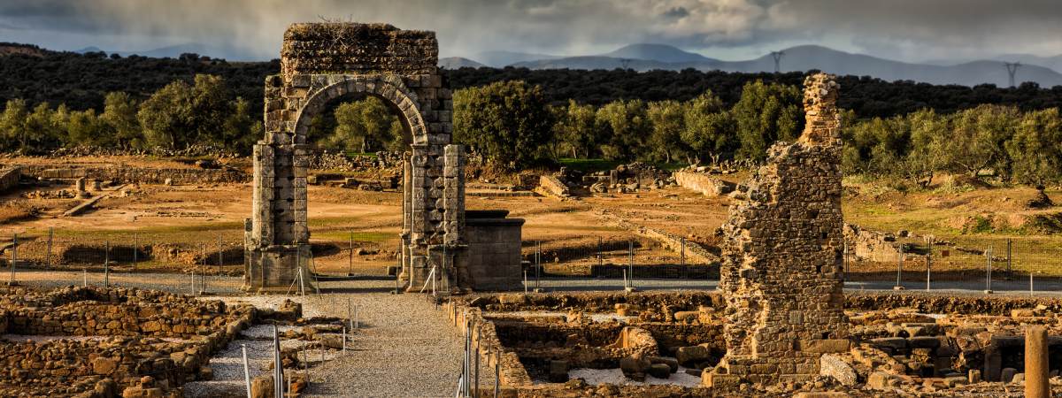
Caparra and its arch are the biggest symbol of the Silver Way in Extremadura. The remains of this city are visited by pilgrims and it is an exceptional celestial viewpoint. Meanwhile ascending to Béjar, Baños de Montemayor is a possible enclave for another mansio, which would have taken advantage of its precious thermal waters. Salamanca/Salmantica and Zamora/Ocelum Durii themselves had these Roman inns. Arriving at the end, the Zamora Castro Gonzalo is the most likely place for the antepenultimate complex.
Other extraordinary locations and landmarks remain on the road or very close to it. Santa Lucía del Trampal, a unique Visigothic basilica, is located in the municipality of Alcuéscar in La Paz. Not far from Mérida and its theatre, the dolmen of Lácara or the reservoirs of Cornalvo and Proserpina are archaeological sites of great interest. Guijuelo, Hervás, Plasencia, Benavente or La Bañeza are more examples of places in La Plata to pay attention to. A heritage site that makes the route a cultural whole.

Santa Lucia del Trampal under a starry sky. | Shutterstock
The Roman road saw some of the fiercest fighting between Muslims and Christians. In fact, the name of Extremadura derives from this frontier condition. At first, the Astur-Leoneses managed to make the Duero the line that marked the war. Zamora, therefore, was a vital strategic enclave. As the medieval advanced, the refounded Cáceres or Badajoz became the centers of attention.
In this environment of continuous conflict, a Jacobean route began to emerge from the south. Still in the 13th century, when Alcántara or Cáceres was conquered and the Military Orders began to become strong in Extremadura, it was of a great danger. This supposed that it does not count on the floor slab of the Primitive Way or the French one. However, it would end up being the best alternative to go to Santiago de Compostela from Andalusia.

Cáparra and the Vía de la Plata. | Shutterstock
Thanks to this, it serves as a kind of multiple-track collector, something that marks the soul of this Way to Santiago. Variants such as the Southern Route from Huelva or the Mozarabic Route from Malaga currently expand the pilgrimage possibilities through a series of perfectly indicated extensions, many based on Roman precedents. The Via Augusta was a sort of predecessor to the A-7 which passed through Cadiz and Seville before continuing eastwards to Catalonia. A branch of the Vía de la Plata connected it with Mérida in Hispalis. This is reflected today in the fact that the Camino usually begins in the capital of Cádiz or Seville, passing through Zafra or Monesterio.
To the north, Astorga was another communication centre. Roads connected it with Zaragoza or Pamplona, among others. It was precisely the latter, which reached Bordeaux, that served as a primitive French Way before the works of Santo Domingo de la Calzada. Outside the Way to Santiago, the aforementioned Via Carisa influenced the creation of the N-630 and the A-66, the Silver Way. Other Jacobean links are found in Zamora or Benavente, which include roads coming from the Mediterranean and Portugal.

Roman spa and thermal baths of Baños de Montemayor. | Balneario de Baños de Montemayor
The route is very demanding. Despite being mostly flat, it is usually lonely and very hot in summer. In the summer, temperatures can easily exceed 40 degrees. Past Zamora, it offers two alternative ends. In Granja de Moreruela, near its famous monastery, there is a fork. Through Benavente and La Bañeza it follows the official route to Astorga, where it joins the French Way. If this option has not been done before, it allows you to get to know two very opposite facets of the pilgrimage.

Granja de Moreruela, monastery. | Shutterstock
On the other hand, you can turn west, bordering Portugal and following the Tera. The Sanabrés Way is extremely old, as the church of Santa Marta de Tera shows. There is the most preterite representation of a pilgrim Saint James, from the 12th century. It passes through places of great beauty, such as Mombuey or Puebla de Sanabria. Then it goes through Ourense, where the Roman past is remarkable and the Portico del Paraíso attracts attention. It also visits the monastery of Oseira or Cea before offering a unique entrance to Santiago de Compostela, precisely on a Roman road.