Picos de Europa in Cantabria, a paradise for hiking lovers


Picos de Europa National Park in Cantabria makes up the eastern part of one of the most extensive protected spaces in Spain, which also occupies land in the autonomous communities of the Principality of Asturias as well as Castile and León.
The mountain massif of Ándara forms the eastern slope of the Cantabrian Picos de Europa; its border is the Deva River, on whose bank you can find the beautiful town of Potes. It is the area with the lowest peaks in the entire park. There are also access roads in the heart of the area, as lead and zinc mines were established there in the 20th century. Traces of the mining activity are evident in the whole area, with remains of buildings; it severely damaged this wonderful landscape, as a 1911 explosion caused the beautiful Ándara Lake to lose most of its capacity.
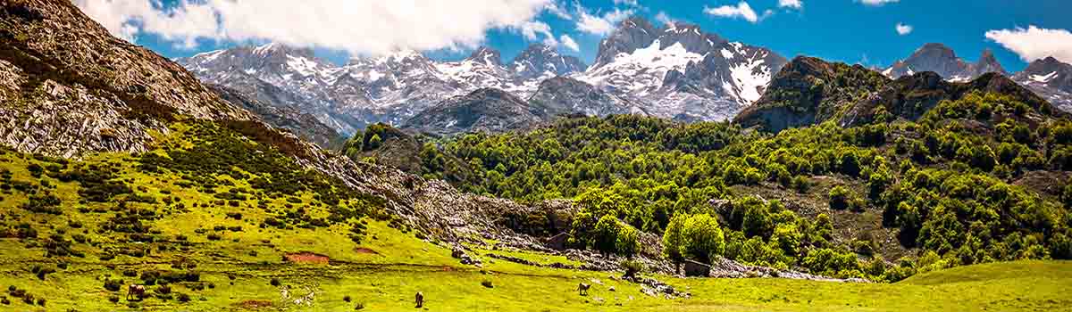
The Cantabrian Picos de Europa share an Atlantic forest ecosystem with the rest of the park which is dominated by oaks and beeches. During the months when there is no snow, the cows of nearby ranchers graze freely in the meadows of the mountains. The fauna is typical to the entire mountain range: many wild boars and roe deer in the lower areas, as well as bears, wolves, and deer. Chamois dominate the more rugged hillsides lacking in vegetation, while otters can be found in the waterways. It’s always a good idea to bring binoculars, as it is possible to watch the bald eagle, the bearded vulture, and the Egyptian vulture in flight.

The town of Potes is the main entrance point to the Cantabrian Picos de Europa. Most visitors then continue on to the town of Fuente Dé, where you can take an 800-meter-high cable car that leads to a plain from which you can enjoy extraordinary views. It is found on the border of the N-621 highway (which joins Unquera with Riaño in León) where the CA-185 splits off, which goes into the protected space traveling through other towns on the way.

In Camaleño
El Urogallo Restaurant
Los Llanos Restaurant
El Jisu Restaurant
In Espinama
Vicente Campo Restaurant
Nevandi Restaurant
Casa Máximo Restaurant
In Fuente Dé
Alfonso XII Restaurant
In Potes
Casa Cayo Restaurant
La Plaza Restaurant
Asador Llorente Restaurant
El Refugio Restaurant
Paco Wences Restaurant

In Camaleño
Hotel El Jisu
Hostal El Caserío de La Liébana
Posada San Pelayo
Posada Las Espedillas
Camping El Redondo
In Espinama
Hostal Nevandi
Hostal Remoña
Posada Casa Máximo
In Fuente Dé
Parador de Fuente Dé
Hotel El Rebeco
In Potes
Fuente de Somave Hotel
Hotel Valdecoro
Casa Cayo Hotel
Hotel La Cabaña
Hostería Picos de Europa
La Viorna Camping
Camping La Isla
Camping San Pelayo

Flight Centre Picos de Europa (Potes)
Active Tourism Happy Emotions (Potes)
Horse Riding Aravalle Centro Ecuestre (Viñón)
Mountain Guides Guiatrek (Ojedo)
4×4 Routes Casa Máximo (Espinama)

Sotama Visitor’s Centre. Av. de Luis Cuevas, s/n. Tama, Cigorillo de Liébana. Cantabria. Spain. Phone: (+34) 942 738 109. GPS coordinates aprox. 43º 10′ 36.47″ N – 4º 36′ 7.28″ W.
Potes Tourism Office. Plaza La Serna, s/n. Potes. Cantabria. Spain. Phone: (+34) 942 730 787. GPS coordinates aprox. 43º 9′ 14.82″ N – 4º 37′ 35.72″ W.