
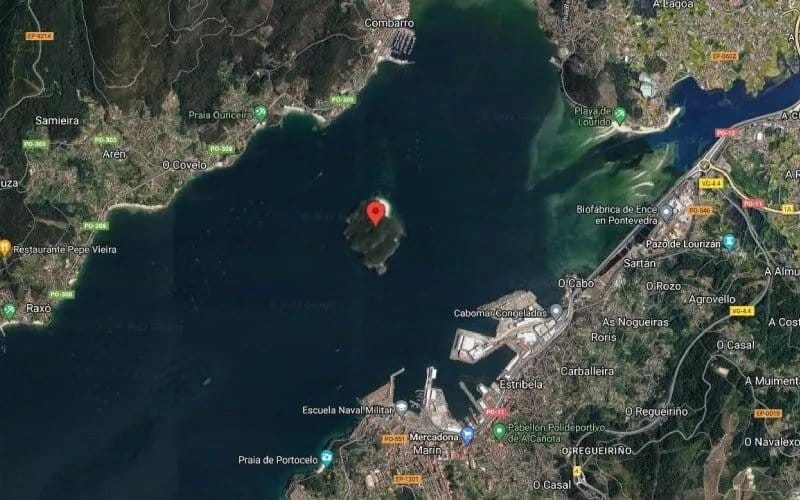
Google blurred this island in Galicia

There are many articles online about the islands of Galicia, and the search engines provide endless results when we look for them. However, there is an island that seems to go unnoticed when we google it, and if we look it up on their maps, we will only find a mysteriously blurred image. The Tambo Island cannot be clearly seen on Google Maps, and yet the traveller will be able to see it as clear as its crystal waters. It is, indeed, one of the thousand paradises one can find in Galicia.

Finding paradise in Galicia (and its islands)
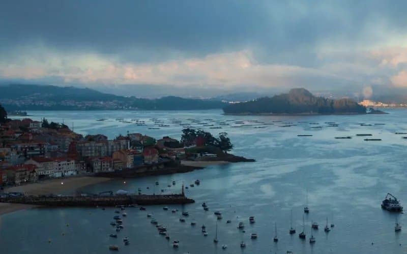
The estuary of Pontevedra opens up to welcome the Tambo Island, which spreads for 28 hectares. The island belongs to the municipality of Poio and it has a pyramid shape, almost completely covered by a cloak of vegetation —especially eucalypti. Its highest point, mount San Facundo, reaches a height of 80 metres. As seen from the ground level, it truly seems like a pyramid.
The Tambo Island will offer us the same thing Galicia generally does: infinite walks where the traveller unveils the connection of this magical land with nature. The surroundings are to be blamed for the paradisiacal essence this autonomous community is best known for, and this little island perfectly illustrates it. It has delightful hiking routes that will lead us for a couple of hours through a silence only interrupted by the smooth waves of the ocean.
One can still visit the ruins of the chapel of San Miguel. This chapel displays the charm of those abandoned buildings that have been embraced by nature. To the north, two gorgeous beaches with clear waters await us. To the south, we have a small peninsula crowned by the lighthouse of Tenlo Chico.
Every corner of the Tambo Island hides stories about pirates and legends about saints that we can learn through a guided tour, although it was only recently that visitors were allowed in the island. Things have changed, and yet the Tambo Island remains mysteriously blurred on Google Maps.
But why did Google blur the Tambo Island?
While trying to unearth the reason behind Google blurring the Tambo Island, one finds out this place is connected to the Naval Military Academy of Marín. This could explain some kind of censorship by Google. The Spanish Ministry of Defence recently acknowledged that the island was used for military purposes between the 50s and the 90s. It served as a manoeuvre area and it held an ammunition dump for storing gunpowder and ammunition. There are still remains of the building there.
However, this theory is still inconclusive. The Naval Military Academy of Marín, which lies in front of the island, does not use Tambo for those means anymore. In fact, the Ministry of Defence handed it over to the municipality of Poio. Since August 2022, they have been offering excellent guided tours that allow us to explore a place that, in many people’s opinion, should belong to the Atlantic Islands of Galicia National Park. Considering all that, the mystery remains unsolved.
Either way, we do know that the value of the cultural and natural heritage of the island is simply immeasurable. Therefore, the tours depart from the harbour of Combarro and only allow small groups of people that have previously booked a visit and should follow a series of rules that have been previously established, like not smoking in Tambo. The visit really is worth it. Before or after enjoying the beauty of the island, one might as well go for a walk in Combarro, one of the most beautiful villages in Galicia —and just another paradise.