
Briviesca

Capital of the comarca of La Bureba
The history of Briviesca has been shaped by its geographical location as a crossroads of Roman roads, obligatory on the way to Santiago and Corredor de la Bureba. A traditional resting place on the trip between Madrid and the Cantabrian Sea, it enjoys a good gastronomy and is emerging as a tourist destination due to the building restorations being carried out.Plan your visit to Briviesca
The greatest points of interest in this emerging tourist destination are its churches, complemented by the other places mentioned in the section “What to see in Briviesca”; it can all be done in a couple of hours. The trip can continue in the direction of the city of Burgos or the town of Ibeas de Juarros. After seeing the prehistoric archaeological site of Atapuerca, you can continue along the Camino de Santiago to Villafranca Montes de Oca, where you can participate in active tourism activities. On the other hand, you can visit Oña and the nearby Montes Obarenes Natural Park.Do you want to visit this place?History of Briviesca
Virovesca, the old name of the capital inhabited by the Autrigones, was one of the main Iberian towns established on the Ebro River in the 3rd century and was mentioned by Pliny the Elder in his Natural History (77 A.D.). The name of the comarca of Bureba, which today comprises 44 cities, derives from the deity Vurovio. Its location at the foot of the roads connecting Astorga, Pamplona, and Irún brought it a certain glory in the Roman age.
In the 11th century, the town which had been slowly growing for centuries due to the presence of several churches became a stop on the Camino de Santiago. However, in that same century, the Camino detoured so as to go directly to the city of Burgos, putting the brakes on the village’s development.
In 1123, King Alfonso VII granted it status to promote its repopulation. Originally, the urban center was situated on the current-day San Juan hill. On September 27, 1305, Blanca of Portugal, the granddaughter of Alfonso X the Wise, acquired the territory and decided to relocate it to its current location; she then proceeded to implement a grid plan uncommon to medieval cities, earning it the nickname “the well-planned [city]”.
In 1387, it was the site of the meeting of the Courts of Castile which created the title Prince of Asturias for the heir to the throne, as a complement to the agreement reached in Bayona to put an end to dynastic disputes in Castile.
The Catholic Monarchs used Briviesca as a model for the urbanization of enclaves in the Americas, such as Santa Fe de Granada.
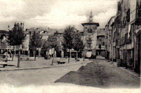
Old photograph of Plaza Mayor with the town hall in the background
Being located on the road that connects Madrid and Burgos to the Cantabrian ports and the French border, Briviesca was a place where travelers and shippers could stop to rest or eat along one of the most trafficked routes in the kingdom, which made possible its prosperity between the 18th and 20thcenturies. The opening of a turnpike meant the loss of a good part of the traffic that had previously passed through the town.
The regent queen María Cristina granted it the title of city in 1894.
Briviesca is very proud of its anthem, which was composed by Friar Justo Pérez de Urbel and premiered in 1929.
The current-day city has expanded the limits of the primitive grid plan, recovering or creating areas of trees as well as attractive promenades.
What to see in Briviesca
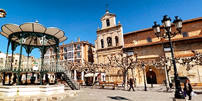
In the center of the original city center is Plaza Mayor, with stone houses surrounding a bandstand. From Plaza Mayor you can take the road leading to the pools to go up to Los Pinos overlook, where you can enjoy the best panoramic view of Briviesca.On the eastern side of the plaza is the tower of the Soto de Guzmán palace (from the 17th century) which has been the seat of the town hall since 1856. To the right you’ll find San Martín Church, a Gothic building refurbished in the 16th century. Its plateresque façade is very deteriorated. The three interior naves are covered with a Gothic-style dome. It houses various tombs and a 17th-century Baroque altarpiece presided over by the figure of San Martín, bishop of Tours. The Capilla de las Viejas, which precedes the sacristy, has a Hispanic-Flemish altarpiece created between 1490 and 1515; the tomb of don Pedro and his wife Teresa Ruíz are found there. The Capilla del Carmen possesses a 16th-century figure of Christ that is highly venerated in Briviesca.
At the beginning of Calle de Medina you’ll find the Casona de los Martínez de España, doubly emblazoned as it also includes the wife’s family crest. This 1718 building is presided over by a façade with a balcony with paintings of angels in the corners and a rococo mythological figure placed above the entrance.
To the right you’ll find the Torre palace with its magnificent crest from the 17th century. The building consists of a rectangular tower divided into four parts and an attached building with a row of balconies from which you can see the arms of the Torre and Ortiz-Vela families.
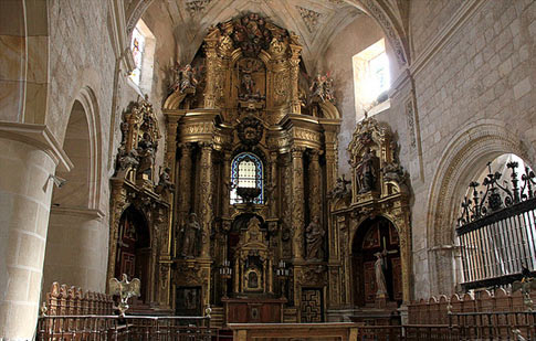
Interior of San Martín Church
By way of Calle Mayor you will arrive at Santa María Church, the first collegiate church in the diocese of Burgos until the 19th century. Its construction was finished in 1794 with a simple neoclassical façade and two towers. Inside there are three naves and baroque décor, baroque altarpieces, and Renaissance chapels such as Santa Casilda which is distinguished for its altarpiece of 11,000 Virgins, made out of walnut wood. It also houses two Gothic tombs with a pointed arcosolium. In 1983 it was declared a national historical-artistic monument, and it can only be visited on Good Friday.
Santa Clara Convent is the most important monument in Briviesca. Founded by Mencía de Velasco in 1517, it is in the Renaissance style, and its monastery, church, hospital, and ancestral mansion extend along Calle del Duque de Frías. The 16th-century convent church, the work of Pedro de Rasines and Gil de Hontañón, stands out. Its 1547 altarpiece was carved from walnut wood by Pedro López de Gámiz.
Along Calle Juan de Ayolas is the renovated Paseo de la Taconera, and from Parque de la Florida and its monument to the Courts and the Prince of Asturias, you can begin the trail that follows the course of the Oca River.
Santa Casilda Sanctuary, 11 km to the northeast, was consecrated in the 11th century in honor of the saint, the daughter of the Moorish king Al-Mamún of Toledo who converted to Christianity and retired here to lead an eremitical life. The current building is from the 16th century, as well as the statue of the saint, the work of Diego de Siloé installed in a baroque altarpiece. Many votive offerings hang from its walls.
Twenty-two kilometers to the southeast is the furrier town of Belorado, which is home to San Pedro Church (17th century), distinguished for its baroque altarpiece, as well as Santa María Church (16thcentury), with a beautiful Renaissance chapel. A short distance away there are the caves of San Caprasio.
Must-see...
Practical Data
PRACTICAL DATA
42º 33’ 00’’ N, 03º 19’ 00’’ W
Burgos 43 km, Vitoria 79 km, Madrid 239 km