
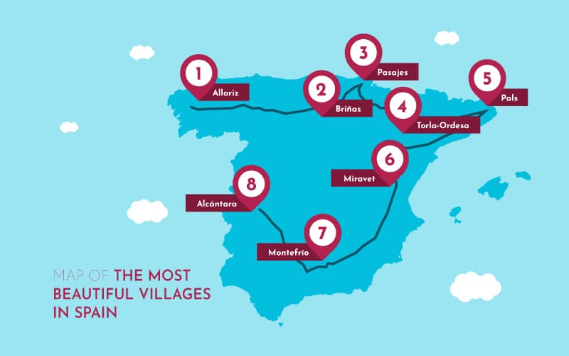
Map of the most beautiful villages in Spain

Maps usually depict the highest peaks, the largest rivers, the most populated cities. It could be said that, from a cartographer’s perspective, the most important thing of all is to picture the elements that stand out the most in the landscape as seen from above. In that case, what happens with the hidden spots which escape that panoramic gaze? What do we do with the subtle nuances that blend in with their own surroundings?

These lines make up a statement in favour of the little things, of the invisible ones, of those places that exist peacefully breathing far from the hustle and bustle of big cities. Villages and small towns tend to be forgotten at many levels, both by the government and by the public eye. Consequently, we have traced a map whose main characters do not necessarily get all the attention they deserve: the most beautiful villages in Spain.
Exploring Spain through its most beautiful villages
Allariz
Our very own compass rose takes us to the north-west of the Iberian Peninsula; more specifically, to the charming village of Allariz. This municipality in the province of Ourense, in Galicia, was declared a Historic-Artistic Grouping in 1971.
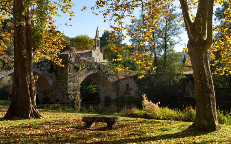
The signature Galician shades of green sprout up from the medieval foundations of Allariz, taking over the cobbled streets and the old stone buildings. A good way of getting to know this village is by walking through the path that goes along the Arnoia river, a winding mirror which reflects trees, fairy-tale houses and Roman bridges such as Ponte de Vilanova.
The walls and fortress of Allariz date back to the 11th century, and they were built under the reign of king Alfonso VI. It’s always a good idea to wander among the ruins of the old castle, breathing in the scents from times past and reminiscing the lights and shadows that have been cast over the ancient rocks throughout the centuries. Not in vain did Sancho IV name this place Key of the Kingdom of Galicia.
Briñas
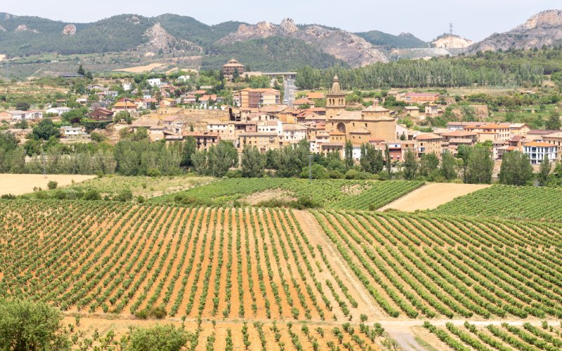
We will travel from the north-west of Spain to the north-west of La Rioja. The red-tiled houses of this village stand on the banks of the Ebro river, surrounded by beautiful vineyards and crop fields. The calm flow of the river once again offers a picturesque view. What is more, less than two kilometres away from Briñas we find the natural channel of Conchas de Haro, an impressive rock formation at the exact point where the Ebro cuts through the mountain range of Toloño.
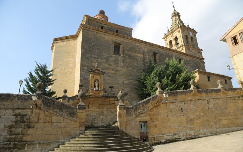
Back to Briñas, we should definitely pay a visit to the church of Nuestra Señora de la Asunción, whose bell tower rises over the tiles and the tree-tops. This historical monument was built between the 16th and 17th centuries, and it has a nave with chapels between the buttresses, as well as a classicist retable.
Moreover, we have the bridge of Briñas, with its enchanting silhouette leaning on the river. Experts believe that this Gothic bridge was built in the 11th century and restored hereinafter, in the 13th and 15th centuries.
Pasajes San Juan
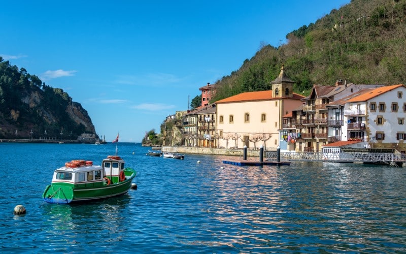
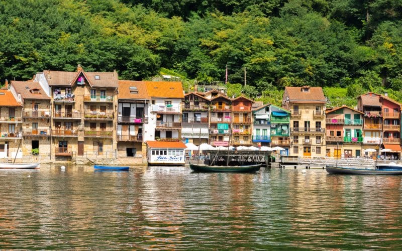
This time we will point our compass to the north-east—more specifically, to the Basque coast. Pasajes San Juan, or Pasai Donibane in Basque, is one of the four villages that make up the municipality of Pasajes. The main reason behind this peculiar division is the fact that the ocean comes into the land forming an estuary splitting the villages of Pasajes. This way, Pasajes San Juan remains isolated from its sisters by a blue stripe which one must cross by boat to get to the village.
This charming spot in Donostia-San Sebastián stands out for its colourful little houses, gathered on a green slope over the sea, a picture that shines with the unique light of Basque fishing towns. In fact, everyday life in Pasajes San Juan is closely related to navigation and fishing, which we can observe by looking at the fishing nets, shipyards and boats that decorate the village.
When we visit Pasajes San Juan, we cannot miss the basilica of Cristo de Bonanza or the churches of San Juan Bautista and San Pedro. The historic house museum of Víctor Hugo, where the renowned French author lived for a while in the 19th century, also offers quite an interesting visit.
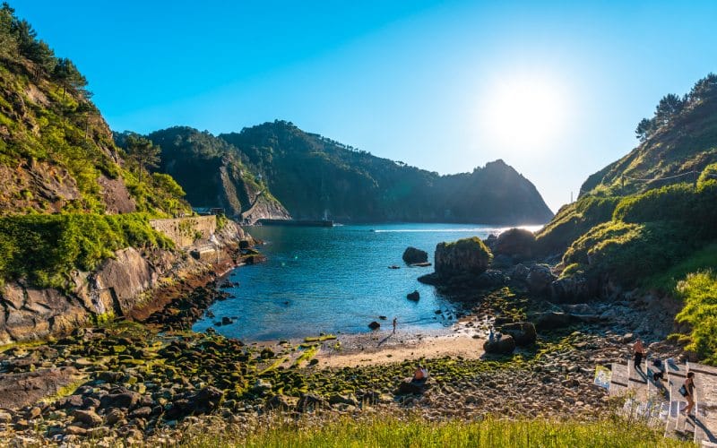
Before we leave, we should take a peek at the wild beauty of the Basque coast, where the fierce sea collides against the steep hills and cliffs. There are some routes departing from Pasajes San Juan which unveil this incredible landscape, passing by a watchtower, a beautiful beach and a magnificent lookout point.
Torla-Ordesa
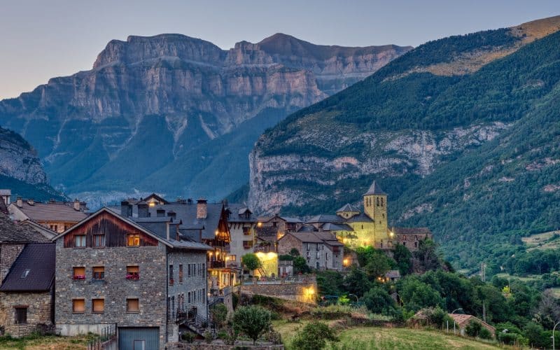
Going along the French-Spanish border we will find this village in the province of Huesca. Its stone houses and towers rise in the middle of the most picturesque scenery, turning this Aragonese village into a fairy-tale dream. In fact, Torla is the gate to the Ordesa Valley, a paradise full of mountains, cliffs, forests and waterfalls in the Pyrenees. It’s no surprise that this landscape was declared a World Heritage Site by the UNESCO.
Torla-Ordesa rests on the bank of the Ara river, near the mountain pass of Bujaruelo. Its location near the border explains why the history of this village is crossed by several battles. For instance, we know it was besieged by the Gauls in 1319. As a consequence, they reinforced the defence measures, predominantly in the 16th century. However, that did not prevent the village from suffering deep wounds in the future. Indeed, Torla-Ordesa fell under the attacks of the French during the Peninsular War and it burnt down a few times in the Spanish Civil War.
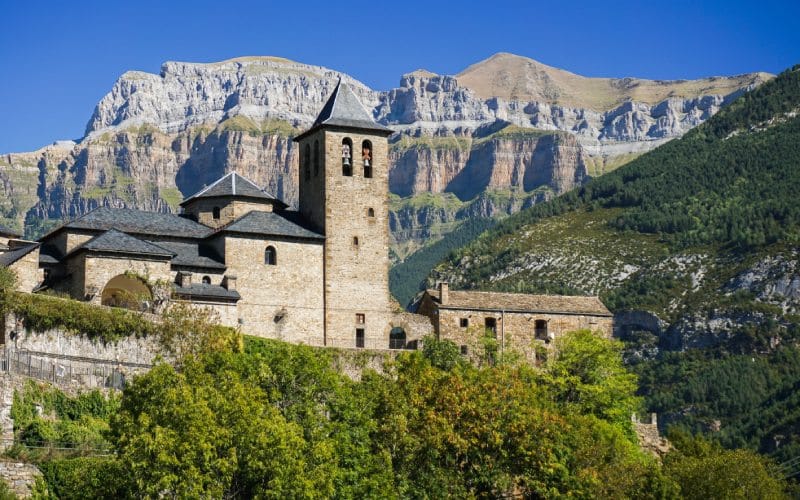
It's hard to believe that, despite everything, there are still remains of the old Aragonese village. For example, we can still visit the ruins of the castle of Torla, mostly preserved inside the Romanesque church of San Salvador. Nowadays, the castle works as an abbey and an ethnological museum. These monuments have survived a thousand battles, and they stand out like fragments of lost stories in this bewitching Pyrenean landscape.
Pals
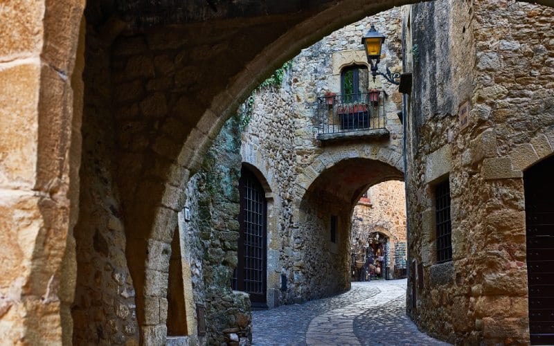
Piercing the neck of the peninsula—in a so non-bloody way—we will arrive at the province of Girona, in Catalunya. If we look around us, we will find a maze of narrow cobbled streets, crossed by archways and cloths of green and purple ivy.
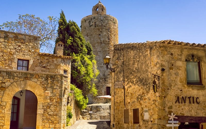
Pals rests on a gentle cliff called Mont Aspre, surrounded by rice fields that stretch to infinity. Its walls keep four 4th-century towers, and in the golden stone castle stands out a Romanesque monument called Torre de las Horas (“Tower of the Hours”). This circular tower, an old watchdog protecting the village since the 12th century, has become a signature element of Pals.
Miravet
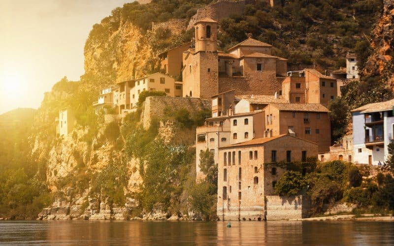
Coming down southwards through the warm Catalan coast, back to the banks of the Ebro river, more specifically in Tarragona, we will find wonderful Miravet. The landscape here curves forming a meander where the village has found a nice place to rest. The old, colourful houses gather on a slope over the river, and the castle rises majestically at the top.
Just like it happened in Torla-Ordesa, Miravet has gone through many a conquest. We know the Moorish conquered it in 715, and the Knights Templar settled there in 1153. The Order of Solomon's Temple was eventually expelled from the castle in 1307, after suffering a long, bloody siege.
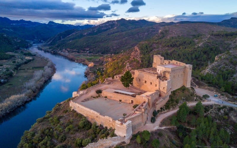
Likewise, the castle of Miravet, built during the reign of Al-Andalus, was later transformed by the Templars. This way, the original fortress got dressed in Romanesque style. The castle was also bombed in 1938, during the Battle of the Ebro. Luckily enough, none of these attacks destroyed it, and we can enjoy a delightful visit to the top of the hill, flying both through history and through the spectacular views we get from the highest point of Miravet.
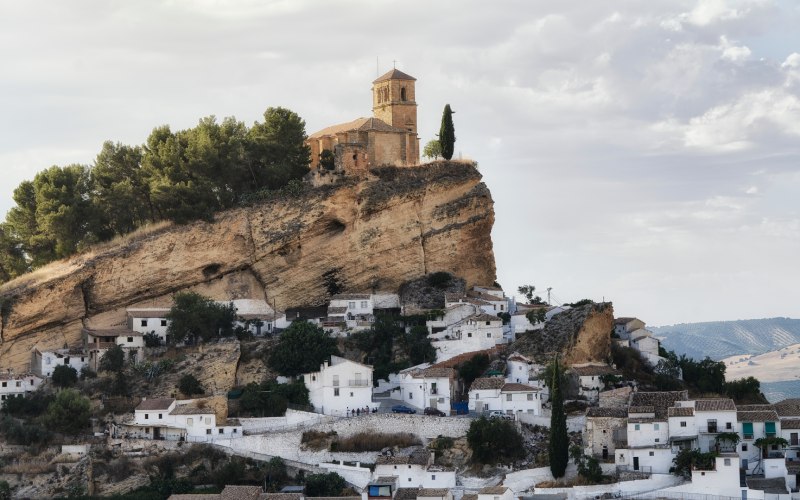
Montefrío
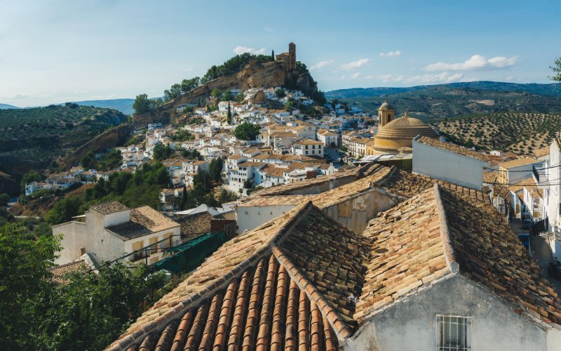
The next dot on our map lies in a warm landscape in Granada. Montefrío is a jewel hidden between olive groves at the heart of Andalusia, whose precious heritage goes back to prehistoric times. In fact, they have found several archaeological remains and megaliths from the Neolithic period in the surroundings of the village.
The element that stands out the most at first sight is the majestic castle of Montefrío, an old stone creature sitting on a rocky hill that rises over the white little houses. This castle was built over a Moorish construction; hence, it displays an interesting architectural mixture.
In 2015, the National Geographic chose Montefrío as one of the villages with the best views in the whole world. The lookout point of the National Geographic to the southwest of Montefrío has framed one of the most beautiful villages in Spain since.
Alcántara
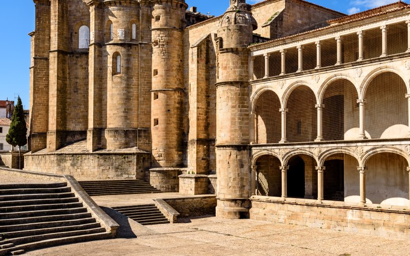
Our last jump on the map takes us to the province of Cáceres. Alcántara is, in many senses, an ode to the past. It’s a dreamy scenery of sleepy ruins peacefully resting under the sun. More specifically, it rests on the banks of the Tajo river, near the border with Portugal.
Both Alcántara and its surroundings make up a historical treasure. In fact, they have found several dolmens near the village, as well as the Tabula Alcantarensis, a bronze plaque which provides evidence of the surrender of the natives to the Roman Empire. We can also get a taste of the medieval past of Alcántara by admiring its castle and fortified complex.
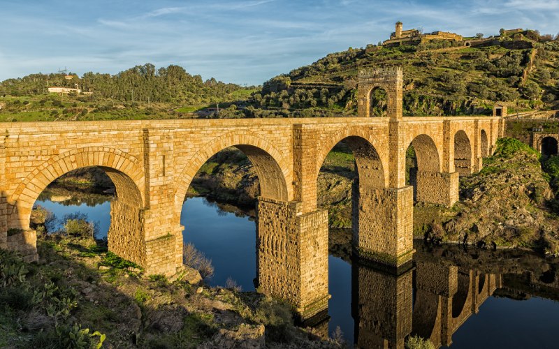
Furthermore, the current name of the village comes from the Arab word “Al Qantarat”, alluding to the Roman bridge of Alcántara. Experts believe that its construction began in 75AD, and it consists of three parts: the bridge, a triumphal arch, and a Roman temple. The beautiful silhouette of the bridge can be admired in all its glory from the lookout point called El Balcón del Mundo (“The Balcony of the World”).
The lines on our map have begun to blur. It’s time to fold it—to take the compass down. This map is only a digression from the complex geographical representations we usually see, a peaceful stroll through some of the most beautiful villages in Spain. A simple, slow picture of the world, painted with the aim of exploring, at least to some extent, the hidden spots that await us on the sidelines of the unknown.