Routes to get lost in the charming Asturias
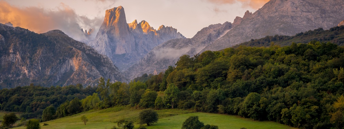

We will find numerous hiking trails through Asturias, crossing the province in multiple directions. Some routes were used by shepherds to move from one village to another, other routes cross rivers, beaches, or mountains, some are examples of local flora and fauna… Undoubtedly, Asturias is province full of charm, which highlights the contrast between the blue of the sea and the green of the mountains. Asturias is magic.
The Cabo Blanco trail can be done starting from Porcía beach or from the town of La Caridad or Tapia de Casariego and has a low difficulty and duration of between two and three hours. The route is the perfect opportunity to get to know some of the most beautiful landscapes of the Asturias and its coast. Starting from Porcía beach, in the Asturian council of El Franco, you will have to walk through a rural environment until you reach the well-known Fonfría Palace, built in the 16th century on top of what used to be an old three-storey tower. After this, you will arrive at Monello beach from where you can enjoy a beautiful viewpoint.

Once the views are over, you must return to the route to find a crossroads from where you can take the direction of Cabo Blanco. From Cabo Blanco you can see the remains of an old fort that dates back to the 4th and 1st centuries BC. It is a natural viewpoint that gives you the opportunity to observe the western coast of Asturias in all its splendour. After a few minutes of reflection, the route continues to the point of La Atalaya, as from this height you will be able to see as far as Estaca de Bares Cape.
Returning on our steps we will reach Porcía beach and with it its viewpoint, from where we can contemplate an amazing marine landscape typical of Asturias, full of coves that extend to Tapia de Casariego. In the vicinity of the viewpoint there is an explanatory panel with the history of a shipwreck in 1928, called Waldemburg.
The Oneta Waterfalls trail is one of the simplest and shortest hiking routes in Asturias and can be completed in just one hour. There are three waterfalls that make up the group, although this route only includes visits to two of them, as the third has a very complicated access.

The waterfalls are located 1,500 metres from the town of Oneta, the starting point of this route. From the southwest end of Oneta, walk 700 metres until you take the path on the left. The walk soon surprises you with an old mill. Further on, another path will emerge on the left, after 1.2 km, on which the first waterfall can be seen, called La Firbia. It has a drop of 15 metres.
To reach the second waterfall, La Firbia de Abajo, you must return to the path and continue walking for about 300 metres through the forest. Hidden among more vegetation, it is the end point of the route.

The longest proposal of this selection is the Teixo route, with almost ten kilometers of journey. Everything you can see on this route, which starts at the Teixo pass in Taramundi, is surprising. From here you have to take the road that leads to Santa Marina. When you see the last houses of Teixo, follow the track on the right and continue until a crossroads with a detour to the left. This way the path becomes a path where you can entertain yourself with nature until you reach the village of Santa Marina. This point is perfect to admire the Asturian rural architecture.

After this point you must reach the hamlet of Almallos, descending through meadows to reach the road that links Taramundi with Veigas. After finding the path that is located here, you will arrive at the Ethnographic Complex of Os Teixois. This complex is an uninhabited village, an example of an industry that stood out in the area in the 18th century. The visitor will be able to see the various ancient hydraulic works.

The next stop is in the village of Las Mestas, which can be reached by a bucolic path that runs alongside a stream. Taking the fifth crossing to the right, you will have to turn right again on a track. Nature will accompany you all the way. To complete the trip, there is nothing like discovering the rich Asturian gastronomy to recharge your batteries in a nearby restaurant.
This is another of the low-difficulty hiking trails in Asturias. Starting from Pesoz, capital of the council called Igual, begins the route of A Paicega. Amongst forests where birches and chestnut trees grow, we reach the village of Sanzo. In this area of the route we must highlight the panoramic views of the castro of Santa Cruz and the valley of Agüeira.

With a low difficulty, the Valle de Lago trail is perfect to do with tranquility. The tour starts in the town of Valle de Lago, in the council of Somiedo. It is a straight path until you reach the Lago del Valle where the route gives idyllic images of flora, fauna, slopes, mountains… The route is part of the Somiedo Natural Park, also known as a Biosphere Reserve.

The first branch is just over two kilometres from the start, where you have to take the path on the right. Along this road you can see teitos, that is, huts with a green roof that are characteristic of the area. One kilometer later, you must choose the path on the right, going along the side of a mountain until you enjoy a spectacular view of the valley from the Gabitón mountain range.

The third branch will come after having walked five kilometres, this time choosing the path on the left, which you will have to cross carefully so as not to trip over the stones. After a while walking you will see Lago del Valle, which you must go around until you reach the highest point of the route.
The Seimeira trail will take us approximately two and a half hours to walk. To begin with, you must cross the village of Pumares from the recreational area of the same name, following the opposite direction to the Agüeira riverbed. Although Pumares is currently dedicated to rural tourism, in the past there was a lot of ironwork activity.

When you reach the first branch after walking a kilometer and a half, you will have to choose the path on the right. This way, Ancadeira will appear on the route, an abandoned village where the vegetation has made its way through the remains of the walls that were built here. After a short trip to the past, you will take the path on the right again, crossing the valley of the Desterrado. At this point, it is advisable to enrich yourself with the history of the place, which can be read on the panels provided there.

Then, another detour to the right will take you in the direction of the Seimeira, Asturias, where you will be surprised by an impressive waterfall. The route of the Seimeira can end at this point or be completed by discovering the village of Busqueimado. To do this, you must walk to just over kilometre three and cross a bridge, turning right first. This small village stands out for its chapel and the yews of the roofs of the houses.
With the passing of time, the sea has carved original sculptures in the rock that can be seen today on the route through the cliffs of El Infierno. A walk through soft mountains where you can see animals such as goats and cows and the breeze that comes from the waters of the Cantabrian Sea in the nearby Ribadesella.

It flows between cliffs, so it is not suitable for those who suffer from vertigo. The exit is located in the recreational area of the beautiful town of Cuerres, near the beach of Guadamia, which is also worth visiting, as it serves as a border with Llanes.
This route does not have a path as such, but follows the coastline between meadows and roads. In the first part of the route along the cliffs of El Infierno you should enjoy a good view of the Bufones de Pría. This is a phenomenon in which water enters the caves below and is pushed out through the jesters. Then, once the kilometre is over, the high cliffs begin to make an appearance. Some of those that rise solemnly on this route are Castro Arenas and Tomasón, among others.

At one point the path offers a detour to the left that leads to the village of Cuerres. However, one should not follow it, but continue straight ahead. After kilometre three, the Palo Verde islet will rise up, with the cliffs of the same name next to it.
Following the coastline and reaching the end of the route, the cliffs of El Infierno appear. Two gigantic stone arches stand out, joining parts of the cliff. To return to the starting point; at the end of the five and a half kilometers a trail with two paths appears. To go back, take the left one, to visit Ribadesella, the right one.