Natural Park of the Western Valleys


The Natural Park of the Western Valleys is one of the most inaccessible areas of Spain. It occupies an area of
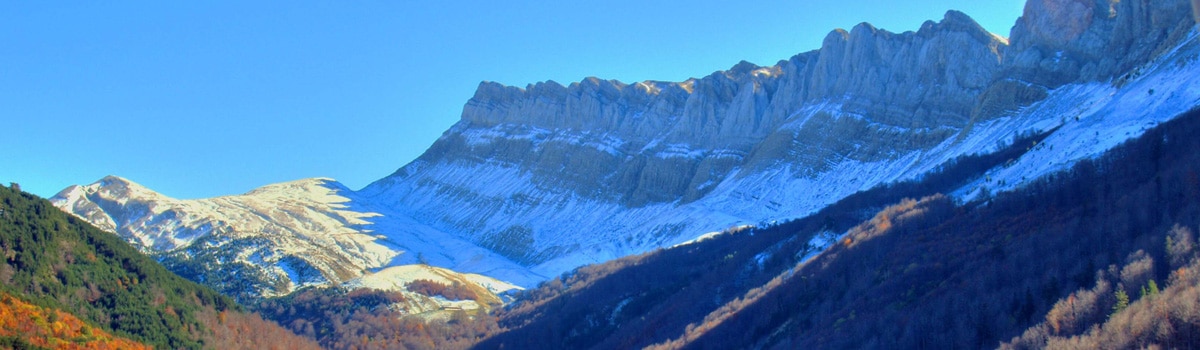
The complex access to the Western Valleys has meant that this territory shows an excellent degree of conservation. It mainly comprises the valleys of Ansó, Hecho and Aísa. Its maximum height in the 2,670 meters of the peak Bisaurín, followed by others like famous Table of the Three Kings, the unique summit called “the Castle of Acher”, the mountain Aspe or Peña Forca. The glacial origin of these western valleys is responsible for the creation of a profuse set in peaks, circuses, U-shaped valleys, karstic formations or ibones (as the high mountain lakes are called, among which are those of Estanés And Acherito).
It is possible to visit places of great natural value in the Western Valleys, such as the Zuriza valley, the Oza Forest or the valley of Aguas Tuertas, with its striking zigzag water currents. In the passage of the man by the Western Valleys it is seen in diverse archaeological elements prehistoric or Roman.
In some areas some of the most unique folkloric forms of language and clothing still survive in Spain. The Natural Park of the Western Valleys are the best example of Aragonese Atlantic forest with leafy masses of black pine, beech and spruce. Highlights such as the Oza Forest or the beech forest of Abi. As for the fauna, the Western Valleys are considered as the last redoubt of the Pyrenean bear; Also has specimens of griffon vulture, bearded vulture, king kite, climbing plants, grouse, wild boar, roe deer, sarrio or marmot.
Hiking and mountaineering are the main activities carried out in the natural park of the Western Valleys. The whole territory is furrowed by a wide network of trails articulated usually around the GR-11, transpirenaico. One of the most famous excursions is the one that leaves from the Jungle of Oza, arrives until the valley of Aguas Tuertas and, for those more seasoned, ascends to the ibón of Estanés.
Access. The valley of Aísa can be reached from the road N-330, that leaves of Jaca towards the north. To reach Done it is convenient to take the A-176, which also leads to Ansó. Through the road A-1602 you will arrive to Ansó crossing the Foz de Biniés, declared Protected Landscape next to Foz de Fago.

In Aisa
Restaurante Borda Juan Ramón
Restaurante Igüer
In Ansó
Restaurante Borda Arracona
Restaurante Borda Chiquín
Restaurante Camping Valle de Ansó
In Hecho
Restaurante Canteré
Restaurante Gabi
Restaurante Borda Bisaltico
In Siresa
Restaurante Castillo D’Acher

In Aisa
Hostal Igüer
Casa Rural Estarrún
In Ansó
Hostal Kimboa
Casa Rural Casa Baretón
Casa Rural Posada Magoria
Casa Rural El Pajar de Pierra
Camping Zuriza
Camping Valle de Ansó
In Hecho
Hotel y Camping Borda Bisaltico
Hotel Usón
Casa Rural Marín
Casa Rural Chuanet
Camping Valle de Hecho
In Siresa
Hotel Castillo D’Acher
Casa Rural Magdalena

Turismo Activo Val D’Echo Activa (Hecho)
Guías Centro de Interpretación del Megalitismo Pirenaico y de la Val d’Echo (Hecho)

Centro de Interpretación de Ansó (C/ Santa Bárbara, s/n. Ansó. Teléfono: 974 370 210 / 974 370 215. Coordenadas GPS aprox. 42º 45′ 25.84″ N – 0º 49′ 43.34″ W)
Centro de Interpretación del Magalitismo Pirenaico y de la Val d’Echo (Ctra. De Oza, km 8. Hecho. Teléfono: 974 375 123. Coordenadas GPS aprox. 42º 48′ 0.64″ N – 0º 43′ 29.42″ W)